Mandsaur
's information is

Birth and death years unknown
Mandsaur is a city and a municipality in Mandsaur district located on the border of Mewar and Malwa regions of Madhya Pradesh, a state in Central India. It is the administrative headquarters of Mandsaur District. The ancient Pashupatinath Temple is located in Mandsaur. Later come under Gwalior state Which was 2nd biggest state. Mandsaur is famous for its opium farming.
* Calculated from Wikipedia data.
Accuracy is not guaranteed.
Mandsaur | |
|---|---|
City | |
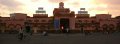
  Pashupati Nath Mahadev Mandir, Mandsaur,
Mandsaur Railway Station building | |
| Nickname: Dashpur | |
 Mandsaur  Mandsaur | |
| Coordinates: 24°04′19″N 75°04′08″E / 24.072°N 75.069°E | |
| Country | India |
| State | Madhya Pradesh |
| District | Mandsaur district |
| Named after | Dashpur |
| Government | |
| • Type | Mayor–Council |
| • Body | Mandsaur Municipality |
| • MLA | Vipin Jain INC |
| • MP | Sudhir Gupta BJP |
| • Mayor | Smt. Ramadevi Gujar BJP |
| Area | |
• Total | 50 km (19 sq mi) |
| Population (2011) | |
• Total | 141,667 |
| • Density | 2,800/km (7,300/sq mi) |
| Demonym(s) | Mandsauri, Mandsaurian |
| Demographics | |
| • Official language | Hindi |
| • Literacy rate | 71.64% |
| Time zone | UTC+5:30 (IST) |
| PIN | 458001/2 |
| Telephone code | 07422 |
| Vehicle registration | MP-14 |
| Website | mandsaur |
Look up "Mandsaur" on WikipediaWikipedia Categories


Loading...